Hó- és zivatarlesen
Sat24 animált mûholdkép
Európai radarképek
Kedves fórumozók!
Egy újabb fejlesztés nyomán az alábbi változás állt be a szakmai fórumok használatával kapcsolatban: A "Hó- és zivatarlesen" valamint a "Hosszútávú esélylatolgatások" fórumok használata ezentúl az ú.n. szakmai joghoz van kötve.
Részleteket ld. a Metnet szabályzat I/7. pontjában.
Módosítva: 2009.07.18
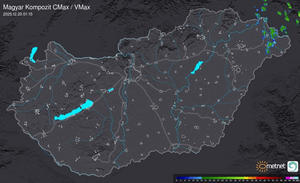

modellek szerint itt fognak szétesni, de nagyon reménykedek  itt hajnali 3-4óra körül lehet valami.
itt hajnali 3-4óra körül lehet valami. 
Estofex:
Link
Egy kis idézet:
"E Austria, Hungary, Slovakia...
Primarily during the late afternoon and evening hours, convection is forecast to develop across these areas. Deep-layer shear of near 20 m/s and MLCAPE of 500-1000 J/kg should suffice for the development of supercells, that gradually cluster into one or two linear systems moving eastward. Most likely severe weather types are large hail and severe gusts. Low-level shear of 10-15 m/s however, suggests that one or two tornadoes will be possible too. A flash flooding threat will exist as well. The convection should become increasingly elevated during the late evening and night and the severe weather threat should diminish."
Erre modom aztatat hogy WOW...
Utolsó észlelés
Térképek
Radar
Aktuális hõmérséklet
Aktuális szél
Utolsó kép
Vasárnap itt az újabb hullámzó front
Időjárás-változás | 2025-09-12 13:30
Szabályzat