Ho-ho-hósirató
Hasznos linkek (és egy infó)
>> Sat24 műholdképek>> Sat24 Magyarország mozgó műholdkép
>> Magyarországi radarképek archívuma
>>Tippelek az előrejelzési verseny aktuális fordulójában!
>>Rádiószondás felszállások élő követése!
>>Észlelés (közeli villámlás, jégeső, viharos szél, villámárvíz, szupercella, tuba, porördög, tornádó, víztölcsér, viharkár) beküldése a szupercella.hu-nak!
----------
Képek beillesztése esetén kérjük azokat megvágni, reklámok, mobilok fejléce, stb. csak feleslegesen foglalja a helyet és áttekinthetetlenné teszi az oldalt - a vágatlan képek ezért törlésre kerülnek.
Fotózáskor kérjük a mobilt fektetve használni, egy keskeny de magas kép egyrészt szintén sok helyet foglal, másrészt a kép sem túl élvezetes.
Köszönjük az együttműködést és a megértést.

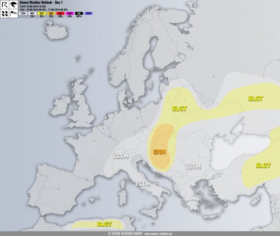
Sw.eu figyelmeztetője mára.
ENH risk has been issued for E Slovenia, N/E Croatia, E Austria, W Czechia, W-CNTRL Slovakia into S
Poland and W-CNTRL Hungary, N Bosnia into NW Serbia with threat for
severe storms, capable of producing severe winds, torrential / excessive
rainfall and large to very large hail. Strong to extreme instability is
again available over the risk area while surface winds should turn into
NNE-erlies. Weak mid/upper-level winds are present aloft. This should
result in elevated storms with back-building, so widespread multicell
storms are expected with the tendency of clustering into a larger system
across the southern half of the ENH risk through the evening hours.
Locally, very large hail will be possible if some storms could gain
better helicity with more easterly flow, as well as flash floods due to
extreme instability and weak storm motion.
Havazás előrejelzés

Utolsó észlelés
Térképek
Radar
Aktuális hõmérséklet
Aktuális szél
Utolsó kép

Újabb mediterrán ciklon érkezik
Időjárás-változás | 2025-11-23 10:49
Szabályzat